


The GDR's rail ferries: Titan's of the Cold War
This is a miniature model of the GDR's rail ferries. They were constructed at the height of the Cold War to transport freight between Germany and Lithuania.
This page is approximately a 5 minute read
Dr. Catherine Scheybeler, Lecturer and Reviews Editor
Dr. Catherine Scheybeler is a Lecturer in the War Studies Department at King’s College, London and Reviews Editor of The Mariner’s Mirror, the international maritime history journal of the Society for Nautical Research. She writes on the Spanish Armada Real, particularly that of the eighteenth century, Enlightenment science and technological change in the maritime world.
In the transmission of knowledge for the greater safety of navigation at sea, technological development sometimes plays as significant a role as the original impetus for sharing that knowledge. One such example can be found among the rare books of the Lloyd’s Register Foundation Library in the form of The Little Sea Torch: or True Guide for Coasting Pilots (1801), a work in which the addition of aquatint engraving, then a relatively new technology, made the information it contained infinitely more useful to seafarers.
The Little Sea Torch was published in 1801 by the marine painter, John Thomas Serres (1759–1825), but at the printing house in Piccadilly, London, of John Debrett (1753–1822), a French Huguenot publisher who is most famous as the original founder of Debrett’s Peerage. The Little Sea Torch contributed to a style of navigation that dated back to the earliest times of seagoing voyages and mirrored the contents of early portolan charts and pilot books. It traced specific sailing routes, in this case through the coasts of Britain, France, Spain, the Mediterranean Sea and the coast of Africa to the Cape Verde Islands, providing important topographical information relating to the sea and its coasts, as well as the landmarks to look out for along the way. Despite the significant advances in hydrography, astronomy and map-making that made life at sea safer by the end of the eighteenth century, guides such as The Little Sea Torch (which did incorporate much new ‘scientifically’-obtained data) continued to be relevant because it was more accessible than other navigational tools which often required specialist knowledge, materials and instruments.
Historically, knowledge of sailing routes was either gained by experience, held by specific individuals and transmitted within their networks, put on paper in manuscript form to allow for a slightly wider audience or, as with The Little Sea Torch, disseminated more broadly through the use of the printing press and engraving. This latter form, again, was nothing new and The Little Sea Torch was, in fact, a translation from a French work by René Bougard (fl. 1684), Le Petit Flambeau de la Mer, a work that went through 14 editions between its first publication in 1684 and its last in 1817. Serres, marine painter to George III, master draughtsman for the Admiralty and regular exhibitor at the Royal Academy, was inspired to translate and expand it into The Little Sea Torch when serving on board HMS Clyde in the Bay of Biscay. As he recorded in the dedication to Earl Spencer, First Lord of the Admiralty, the ship’s commander, Sir Charles Cunningham (1755–1834), ‘put it into my hands with the warmest commendation of its contents, declaring that if I were to give a version of it, I should be doing an essential service to my country, and that if the appearances of the Headlands and Charts, were equally well executed as the descriptive parts were just and accurate, it would be one of the most valuable books ever published’1.
Explore pages from The Little Sea Torch
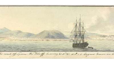
In many respects, Serres was uniquely placed to produce such a work. As the son of Dominic Serres (c. 1722–1793), from whom he inherited the position of marine painter to George III, he had travelled extensively in Europe, including on several of the voyages of the royal yachts and a five month residence in Rome. More immediately, from 1799 to 1800, he had been employed in the Royal Navy’s Channel Squadron surveying the coasts of Britain, France and Spain for the Admiralty. As a result, his watercolour sketches, distilled into 137 coastal profiles, were to take centre stage in his translation of Bougard’s work, surpassing both the translation of the text (which included updates and amendments) and the 24 harbour charts, which were drawn by the cartographer and engraver John Luffman (1751–1821).
The difference this made to the transmission of navigational knowledge is amply demonstrated through even a cursory comparison of Serres’ finely executed aquatint plates with the rather unclear woodcuts that continued to be used in Bougard’s work up to 1817. It was the use of aquatint engraving, developed in the mid-eighteenth century and increasingly used from the 1770s, that made the difference and that allowed for a detailed and accurate translation of Serres’ original sketches onto the printed page. This was done by Joseph Constantine Stadler (1755–1828), a German emigré who arrived in Britain sometime around 1780 and worked with many of the principal artists and caricaturists of the period in London. The process was laborious and expensive but the method of production, in which Stadler excelled, could achieve gradations of tone that were not possible with other forms of engraving and which imitated the effect of a watercolour wash, giving the technique its name of aquatint.
Aquatint coastal profiles had been done before, usually included within charts or atlases such as with Des Barres’ The Atlantic Neptune (1776–1781), but it was The Little Sea Torch which gave them prominence thereby highlighting their importance to navigation and capitalising for them the benefits that could accrue from the use of aquatint. Serres, in effect, had used modern technology to add a level of detail and clarity to René Bougard’s original work that the latter could not have imagined in 1684 but would no doubt have appreciated.
Barritt, M. K., Eyes of the Admiralty: An artist in the Channel Fleet 1799–1800 (London: National Maritime Museum, 2008)
Bougard, René, Le Petit Flambeau de la Mer, Ou le véritable Guide des Pilotes Côtiers ... (Saint Malo: L. Hovius, 1817)
Gascoigne, Bamber, How to Identify Prints: A complete guide to manual and mechanical processes from woodcut to inkjet (London: Thames & Hudson, 2004)
Hoisington, Rena M., Aquatint: From its origins to Goya (Princeton: Princeton University Press, 2021)
Hornsby, Stephen J., Surveyors of Empire: Samuel Holland, J.F.W. Des Barres and the making of The Atlantic Neptune (Montreal: McGill-Queen’s University Press, 2011)
Russett, Alan, John Thomas Serres, 1759–1825: The tireless enterprice of a marine artist (Lymington: Sea Torch Publishing, 2011)
Serres, John Thomas, The Little Sea Torch: Or, grue Guide for coasting pilots ... Translated from the French of Sieur Bougard, with corrections and additions (London: J. T. Serres, 1801)
Tracy, Nicholas, Britannia’s Palette: The arts of naval victory (Montreal: McGill-Queen’s University Press, 2007)
J. T. Serres, The Little Sea Torch (London: J. T. Serres, 1801) p. ii
This is a miniature model of the GDR's rail ferries. They were constructed at the height of the Cold War to transport freight between Germany and Lithuania.
Explore the behind the scenes process of filming the Argentina, a 'votive', the Aeolus and the East Indiaman ship models at the National Maritime Museum, Sweden.
Explore the behind the scenes filming of the Cold War Rail Ferry, Oasis of the Seas, Stena Drillmax and Olympic Loyalty ship models at the IMO's headquarters.

